Thursday, July 29, 2010

DeTour Village

Waiting out the weather in Little Current paid off as the next three days brought us calm waters and sunny skies. We anchored in the Benjamin Islands, a North Channel favorite. The sparkling blue water, pink granite rocks and wind swept pines were picture perfect.

We found a tiny secluded cove and had it all to ourselves.

The wind had kicked up in the afternoon, as it often does here, so we restricted our dinghy exploring to the immediate area. The water was incredibly clear as you can see here.

We found a rocky beach, took a stroll and collected a few rocks.

The small rock island across from the boats was beautifully reflected in the water the next morning.

Leaving the Benjamins, we passed the "Sow and Pigs" rock formations at the entry.

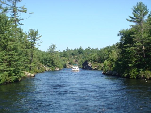
The next day we cruised through Whaleback Channel, off the northern side of the North Channel. Again, spectacular beauty ...

and pristine shoreline.

This is Whaleback Island.

There are hundreds of anchorages in the North Channel and we only got to sample a few, but after one more night's stay in Canada, we set off to re-enter the US. The water was totally calm for our 45 mile crossing of the North Channel, which brought us through islands on the American side. The water had turquoise hues that didn't really show up on the camera. Looks like a palm tree on the shore of this island.

Boats returning from Canada are required to report in at the US Customs Office at the Drummond Island Yacht Haven. Our papers were all in order, so they let us back in ...

... and as we cruised away, I took down the Canadian courtesy flag.

We anchored for the night in a large cove on Harbor Island, part of the UP (upper penisula) of Michigan. It felt good to be back in the USA and in the midwest.

A big blow came through in the night and our anchor, holding both Shingebiss and Eschaton, dragged us back a ways during the night. Good thing there was plenty of room and no boats anchored behind us. After a night of banging and bouncing, we were ready for some quiet at DeTour Village Marina. The marina is located in the DeTour Passage, which connects the North Channel to Lake Huron proper. The Michigan DNR harbor system runs 83 marinas that span all 3000 miles of Michigan Great Lake shoreline. Our slip here was only $35, and that included everything, so we think it's a pretty good deal they have going here in Michigan.

We've toured the entire town, it's small, but charming and hospitable. We've met all sorts of other cruisers here, including this creative bunch of locals who built their craft, powered it with an outboat, and included a wood fired hot tub to provide maximum comfort for the crew. It was dusk when they came by last night, so the picture is fuzzy, but you can clearly see the heads and shoulders of the four in the hot tub. American ingenuity at its best.

Friday, July 23, 2010

Little Current - North Channel

From Killarney we entered the famed North Channel of Lake Huron. Here's a picture of us cruising, taken by Eschaton. We had a short cruise that day into Covered Portage Cove for our first North Channel anchorage. Note the mountains in the background.
The hills have gotten much higher and have turned to white, we are told they are quartz. Covered Portage Cove is one of the most beautiful anchorages we've ever been in. Because the water is deep to the shore and the anchorages are sometimes crowded, we anchored the boats using the med mooring style. After dropping the bow anchor, Steve brought a long stern line to the shore with the dinghy and tied it to a tree. This was the view from our bow.
Later in the day, we dinghy'd to shore and hiked up a well marked trail to the top. We were rewarded with this spectacular view of the cove.
The next day we were headed for an anchorage at Baie Fine, a 10 mile long "fiord" like gorge. After hearing the wind prediction, we decided to give Baie Fine a "drive by" and then head for a marina. A few miles up the Baie, we dropped the anchor in a small cove with this view across from us.
We hopped into the dinghy and went up the to "the pool" at the end of the Baie where we had this view. Looks like snow capped mountains, eh?
The North Channel, bordered by the mainland of Ontario on the north and Manitoulin Island (the largest fresh water island in the world) on the south, is about 140 miles long and 30 miles wide. The open water makes for great sailing and, like Georgian Bay, the beautiful anchorages are limitless. We are currently spending 3 nights at Little Current Town Marina on Manitoulin Island. Little Current is the largest town on the island and is situated in a narrow passage between the east and west parts of the North Channel. There are hundreds of boats here, all occupied by cruisers who roam the docks meeting, talking and eating ice cream all day long. The marina has a long wide boardwalk along the shore, with picnic tables, big rocks, a party shelter, yacht club, and gardens behind the boardwalk. Here's a couple of shots of the marina.
The main street is just steps away with one of the more interesting shops I've been in. Turners is one of those small town merchandise stores that sells just about everything you can think of, including quality local arts and crafts upstairs. It's been owned by five generations of Turners. I had the pleasure of talking with Debby Turner, who told me more about the history of the family, especially Barney Turner, her father-in-law. It seems that American companies have several times made attempts to cut into and mine the beautiful granite and quartz hills of the area. Thoughout his lifetime, Barney was a leader in the battle to preserve this pristine wilderness, opposing the industry and then lobbying for legislation to ensure its preservation for generations to come. He was a well loved man in the North Channel.
There's always something happening in Little Current. The Yacht Club features a Happy Hour with free snackies every day at the Anchor Inn, the Pantry offeres $5 breakfast and today there's the Mackinaw - Manitoulin sailboat race that will finish right in front of the marina ... should be exciting. Weather permitting, we should be back in the USA in a week at the most.

Tuesday, July 20, 2010

Georgian Bay - Part 2

Other Loopers have often told us that "the best is yet to come" in describing Georgian Bay and the North Channel. We did not give it much thought because we were enjoying where ever we were at the time ... but we have to admit now that it's true. We saw far fewer cottages as we cruised to our anchorage in the Bustard Islands. We took the dinghy up this back channel with beautiful rock shores ...

... huge boulders and the pine trees grow right up out of them.
Steve found a wild blueberry patch and we had blueberry pancakes with Nan and Jack.

The next day we had an 18 mile open crossing with flat water and blue skies. We entered Collins Inlet, a 10 mile long narrow cut at the top of Georgian Bay. The rock walls were even higher...

... and higher.
... and the passages were narrow. I took a very short video and it's at the end of this entry.

The town of Killarney, Ontario is an old fishing village in the channel that connects Georgian Bay with the North Channel (both part of Lake Huron). The town was accessible only by water until a road was constructed in 1962. The road is 50 miles from a connecting road, so the town remains fairly isolated except for boaters and those who come to hike and camp in the Killarney Provincial Park. This lighthouse marks the entrance to Killarney Channel.
One of the highlights of a visit to Killarney is a fish and chips dinner at Herberts Fisheries. The fish is caught daily and unloaded from this boat ....

... and fried up with tasty "chips" in this bus.

Big portions and quite tasty.

Other than Herbert's there's not much to see in Killarney and the WiFi at the marina worked so poorly that we couldn't get a blog off, so we set off the next day for some North Channel cruising.
So check out the quick video and don't forget to read the second blog, as i'm again doing two entries.

Sunday, July 18, 2010

Georgian Bay - Part 1

The southeastern end of Georgian Bay is only a couple of hours from Toronto by car and easily accessible from the TSW by boat, so is the most populated part of this incredible cruising ground. Beausoleil Island is the largest island in this section of the Bay and is a Canadian National Park, so that's where we headed for our first anchorage. We were a little surprised to find at least 70 boats anchored in the protected anchorage, but it was a Saturday and by Sunday night all but eight of them had left. We spent the next day hiking on the island and swimming in the clear water.

Georgian Bay is the land of 30,000 islands, not an exaggeration by any measure. The anchorages are plentiful and all the scenery is "drop dead gorgeous". We came through a narrow passage to enter this very pristine and isolated anchorage at Echo Bay. A cloudy day, but still beautiful.

There is a "small craft channel" that runs through the islands with an occasional short outside run. It is very well marked, but the captain must keep constant attention on the markers and the charts with all the twists and turns. Sometimes the channel is quite narrow, this is called Canoe Channel.

Our next anchorage was at Regatta Bay, where we stopped to visit Looper friends, Peter and DiDi We had met them on their boat, Moon Beam, way back at Hoppie's last fall and they invited us to their cottage right across the channel. We dinghy'd over and they gave us the royal treatment, feeding us a delicious dinner and letting us use their car the next day to go for groceries. It was great to see them and share Looper Tales. Here we all are on the deck of their beautiful cottage ...

... and here are the boats at Regatta Bay.

At our next anchorage, Bayfield Inlet, we stayed put for three nights waiting for the winds and waves to settle down enough for us to make an eight mile "outside" run. We had the anchorage to ourselves and did some dinghy exploring in the maze of channels. Most of the cottages are on islands, often only one cottage per island. The cottagers have to come by boat, so there are lots of little boat marinas where they keep the boats and their cars. Today dawned bright and sunny and the winds had settled, so off we went. The scenery remains spectacular. Here are several pictures of the shoreline we went by today.


After our marathon of nine days anchored out, we are in St. Amant's Marina in Britt, Ontario tonight, enjoying the WiFi. I've done two blog entries today, so if you missed the exciting conclusion of the TSW leg, be sure to scroll back. We're about 2/3 of the way up Georgian Bay and will blog again next chance we get.

Trent Severn 12-13

We got a late start out of Orillia and stopped for a pump out since we located a marina with $10 pumpouts. It's best to ask in Canada what the charge will be; one marina quoted us $45 for this most necessary service, so the $10 was looking pretty good. The western end of the Trent Severn Waterway was the last part to be built. The biggest cut through the granite rock is at McDonald's Cut; imagine excavating this cut by hand in 1905. The day was again cloudy, so the picture does not quite show the beauty of this section of the canal.
We went through Swift Rapids Lock, the tallest one on the TSW, with strong rapids at the bottom end. Our goal was to secure a tie up at the Big Chute, a highlight of the TSW. The lock tender at Swift Rapids called ahead and told us there was room.
These are the rapids next to the Big Chute. Again, cloudy day. The next day was clear and was our last day on the TSW.

The Big Chute was the last lock completed on the TSW. It was originally designed as a "temporary measure" in order to finish the waterway. As you can see, it's really not a lock at all, but a giant "travelift on rails" that you drive your boat onto and they lift it over the land. Here's a 47' Bayliner coming onto the chute car on the upstream side. They tighten the slings to hold the boat in place. They can also divide the slings into two or three abreast to take the smaller boats through. We were there early on a Saturday, so no crowds yet, but they are very efficient.

Once the boat is secure, the Chute comes up on the tracks. The back wheels and front wheels each ride on a separate track, so the boat stays level as it travels uphill to the top, which just happens to cross a road ....

.... and then down the other side, where they lower the slings and you cruise away.

Most newbies, like us, stop to watch it work a couple of times and go to the Visitors Center. We learned that in the 1970's, they were going to replace it with a regular lock. At this time, the lamphrey eel was invading the rivers, so Canada decided to leave the Chute as is in hopes of keeping the eels out. Next it was our turn. Here's the view from our flybridge at the top of the Chute. Notice the two separate tracks. Cables are attached under the lift to pull it up and lower it down ... slowly.

We drove off with Eschaton close behind.

Below the Chute are more narrow, beautiful rock gorges, with some swift current. It is advised that you give a "security call" on the VHF radio when you enter these cuts, so that you don't meet another large boat head on.

The last lock on the TSW is the busiest lock on the waterway. At just 80' long and 22' wide, it's also the smallest. On this busy Saturday, we had to pull up to the crowded "waiting wall" and wait our turn. The lockmaster tells each boat when to come in and in what order. They can only take one big boat at a time, and then bring as many small boats in as will fit. As you can see, they really pack 'em in. It's now a historic site, so they couldn't make it any bigger if they wanted to. Oh well, the whole place had a festive air about it and everyone shows patience and good cheer.

We got through and it had been a long day of cruising. We weren't done yet, we had an anchorage on Georgian Bay picked out so off we went. We had thoroughly enjoyed the TSW, but were looking forward to some "lock free" cruising.


As you know, we're depending on WiFi to blog from Canada, and it's been 10 days since our last, so i'll do a separate one on our first half of Georgian Bay after this one is published.