Saturday, June 12, 2010

(Fresh) Waterford, NY

We left Kingston on a beautiful day with no wind and flat seas. As we moved north, we could see the Catskill Mountains on the western shore of the Hudson.

The few tugboats that we've seen are pulling their barges rather than pushing them.

We anchored for the night in the Schodack River, one of the tributaries to the Hudson. Commuter trains to NYC run along the east bank of the river.

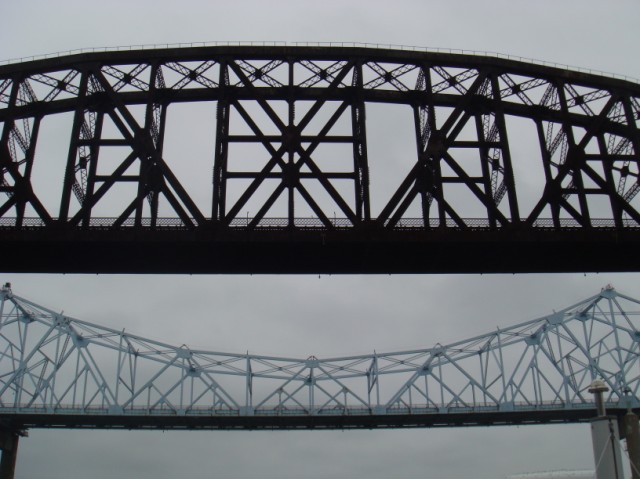
Rain was predicted to start at noon the next day, so we got an early start hoping to get docked before it hit. We passed through Albany and finally saw some industry. The pictures just don't look good without the sun, but these two bridges close to each other made for an interesting image.

It was pouring rain when I went out on the front deck to lock through the Troy Lock. Instead of ballards, this lock had vertical pipes tucked into indents in the lock wall. Captain Steve pulled the boat smoothly to the wall and I just cleated off a line at midship, wrapped it around the pipe and held onto the other end. The water rose quickly (30'), the rope slid up the pipe, and we exited the canal into FRESH water with no tides for the first time since 11/19/09. The rain let up a bit as we passed by this sign.
At this point, Loopers must make a decision. Go straight into the Champlain Waterway or turn left into the Erie Canal. We turned left and were pleased to see that there was room for us at the docks in the Village of Waterford. Not only are the docks free for 48 hours, they also provide electricity, water, restrooms and showers, WiFi and a book exchange. What a sweet service !! The rain started in again, so we spent the afternoon planning our trip through the Erie Canal and ordering charts for Lake Ontario and Lake Huron ... oh, and taking naps too. What a life !!

Wednesday, June 9, 2010

Halfway up the Hudson

The next segment of our Loop is the 150 mile journey up the Hudson River, tidal all the way to Albany. The rising tide actually overpowers the river current; the Native American name for the Hudson means "the river that flows both ways." Northbound mariners time their cruise to catch the tide rising in order to get a boost. The optimum time for us to leave wouldn't have been until about 2 pm, but we were too anxious to get out of the NY Harbor wakes so we left early. We were bucking a 2 mph current for the first couple of hours and were crawling up the Hudson. Here's a last look at Newport Marina in Jersey City.

The river was busy, but it's wide and there is room for everyone. We had another look at the Manhattan skyline with the Empire State Building rising above it all. We marveled at the sheer numbers of skyscrapers until we reached the northern end of the island.

The double decker George Washington Bridge is near the northern tip of Manhattan. As you can see, the scenery changes dramatically beyond this bridge.
Suspension bridges are very common here and the George Washington is particularly impressive.

The banks of the Hudson are steep, heavily wooded and feature beautiful stone cliffs that go straight down to the water. We anchored for the night in front of Bear Mountain, part of the Interstate Park System that lines the western shore. This cove was so peaceful and natural it was hard to believe that we were only 40 miles from NYC.

We had read about the trail to the top of Bear Mountain, so the next day we packed a lunch and set out in the dinghy for the park dock. The park has been around for a long time and tour boats used to come from NYC to this sturdy dock. Note the bridge in the photo, we'll see this bridge from the top after our climb.
In addition to its many hiking trails, the park also has a zoo, museums and this huge swimming pool nestled into the hill. An old lodge on the grounds, originally built by the WPA is currently being restored.
The mountain is about 1300 feet to the top. The main trail, with many switchbacks, includes 800 stone steps put in by volunteers who hand cut the native rock and set the stones in place without heavy equipment. It's very impressive, this section is especially nicely done.

Even with the steps, it was a long hike up, but the views were worth it. Looking upstream, note how far we are above the bridge in the lower right corner.

The view downstream ...

... and the small white speck near the bottom shore is Shingebiss at anchor.
Near the top, we ate our lunch on this bench.

It was a great hike, but we were outa gas by the time we got down the mountain and back to the boat, so we elected to stay another night in this beautiful setting. We set out early the next day with cooler temps. The mountains continued with homes interspersed along the cliffs. With the Hudson River's long history of commerce, we had expected more industry and more commercial traffic, but instead found a serene and peaceful river. We were finally catching a boost from the "upstream current", the water was like glass and we were loving the Hudson.

West Point is right on the banks of the Hudson and it's mighty impressive. The older parts of the complex look like a fortress and the stone work is beautiful. Before 9/11, cruisers could pull right up to the dock for a tour, but no more, so on we went.

These ruins are Bannerman Castle, built on an island in the early 1900's by Frank Bannerman as a resort. In the 1960's New York State obtained the property and gave tours, but the castle burned and is now badly deteriorated.

The Hudson has some old lighthouses.

This lighthouse stands at the entrance to Rondout Creek. By this time it was raining, and we had put up our "plugger windshield". After the last time we got drenched on the flybridge, we had bought a few yards of heavy clear plastic (Joann Fabric, who knew?) and a bag of heavy duty clips. Visibility is not the best and there's no fancy zippers, but for $20, it keeps us dry.

Of course, we had to take it down before we entered the town of Kingston. Once we got to Hideaway Marina and met the owner, however, we realized he probably would have admired our ingenuity. Inexpensive and very down home, it's not fancy, but works for us. We've been able to ride our bikes for groceries much of the trip, but too far today, so we took a cab, bought a ton, did laundry, and cleaned the boat inside and out. For some reason these routine chores are more satisfying on the boat than they ever were at home. We love the feeling of setting out with fresh provisions, clean boat and clean clothes, an empty holding tank and a full water tank and a new destination on the horizon.
For those of you following the Exploits of the Eschaton, they moved on ahead of us, but are leaving their boat for 9 days for a road trip home to Tennesee. They hope to catch back up with us before Lake Ontario.

Sunday, June 6, 2010

The Big Apple

We made it to New York City !!! The trip started with some excitement as we exited the Manesquan Inlet into the Atlantic Ocean (there is NO inside route). The waves in the Inlet were huge, we almost buried the bow as we came out and we held our breath as we watched the Eschaton exit. They took water over the front windows of their Gibson, but there was no turning back so they pushed on through the Inlet and into the calmer water in the ocean. We traveled up the New Jersey coast and into the lower harbor of New York. We rocked and rolled pretty much for the whole trip, but it was tolerable and we were excited to see New York. The Verrazano Narrows Bridge marks the entrance to New York Harbor and the Hudson River.
We could see the skyline of lower Manhattan in the distance. This harbor is busy, busy, busy. Ferries, tour boats and commercial craft of all kinds. It was Saturday and we saw more sailboats actually sailing than we've seen in one place the entire trip.

We saw the Statue of Liberty ...
... and then we took turns taking pictures of each other's boats. Here's the shot Eschaton took of Shingebiss ...

... and then this fire boat came by ...

... and then the fire boat drove in front of Lady Liberty and we thought "wow, what a show".

We had plans for a two night stay at Newport Marina and Yacht Club in Jersey City, right across the Hudson River from Manhattan. Jersey City is has its own share of skyscrapers, but you can see the marina here at the base of the tall buildings.
This is the view of Manhattan we have from the docks. The "wave barrier" in the picture is supposed to break the wakes from the many huge boats, but it's still one of the bounciest marinas we've ever been in. The waves do settle down at night; the view is worth it and it's spectacular at night.

Diane and Tom (Noah Genda) also came in, so the six of us made plans to take the PATH train, which goes under the Hudson River into Manhattan today. We took a double decker bus tour of "downtown". What a great way to get an overview of this incredible city. Steve and I have never been to NY before and we were amazed all day at the architecture, the people, and the history that was related to us by our tour guides. You can hop off and on the bus at any of the 23 stops, so we got off at the World Trade Center site and St. Paul's Chapel where the congregation coordinated a huge relief effort that lasted for months following the attack. The fence surrounding the church is where all the survivors brought mementos and photos to honor the victims. The chapel has preserved all these and has them on display. It's very moving.


We walked past Wall Street and the famous bull where tourists were all taking pictures. So we did too.
At the south end of Manhattan is Battery Park which has an old fort and the landings for the tour boats to Liberty and Ellis Islands.
We walked to the shore and saw that the harbor water was extremely rough. We were all glad to not be out there in our boats today.

We got back on the bus which took us by many other NY highlights: the UN building, Rockefeller Center, Times Square, Madison Square Garden and the neighborhoods: Chinatown, Greenwich Village, SoHo, Little Italy and the Theater District. Wow, we were overwhelmed, but very glad we had taken this tour. We found our way back to the PATH train and our marina in Jersey.
Tonight we continue to enjoy our awesome view and tomorrow we head up the Hudson River.

Friday, June 4, 2010

New Jersey Cruising

It was a little foggy as we departed Cape May early in the morning. As we exited the Inlet, we passed this large dredge being towed in.

As soon as we got ~2-3 miles off shore, the fog thickened, and we were dependent on the radar to show us other boat traffic. With light winds, there were no "waves" or whitecaps to be seen, but there were giant, gentle swells that lifted the boat up. When we surfed down the other side, our speed increased by 1 knot. All in all, it was a comfortable ride with the swells on our starboard following quarter. It was 50 miles to Atlantic City and the fog began to lift a little as we approached.

We made our turn into the Absecon Inlet and got a better look at the city and the beach.

We turned into the New Jersey ICW and the scenery immediately changed. Of course, the places we visit never look like what I have pictured in my mind, and our anchorage at Fish Island was a great example that made us laugh. Here it is: Fish Island, about a city block in area and 8" above sea level. Not too scenic, but it was just enough to break the waves.

We woke up the next morning to dense fog and went back to bed. Traveling in the open ocean in fog is one thing, but on this ICW, where the markers in the water do not always match the markers on the charts (due to the constantly shifting shoals) and the necessity of "reading the water" make traveling in fog impossible. By 10 am it had cleared so we left the lovely Fish Island anchorage. In this piture you can see one of the many shoal areas as the lighter colored water about midway up the picture.
Although we didn't run aground, we did see spots of 3.5 feet of water in the channel. Traveling the NJ ICW is slow and tedious. Because of the need to travel on a rising tide (that way if you run aground, the rising tide will help lift you off) and our late start, we had a short travel day. With thunderstorms predicted, we opted to stay at Beach Haven Yacht Club Marina where we had gotten fuel for the great price of $2.50/gallon. Eschaton joined us there and we walked over to the beach. We were pleasantly surprised ... who knew that had such pretty beaches in NJ ??


Today, we continued our run on the NJ ICW and are now anchored just a few miles from where we have to exit again into the Atlantic for a 44 mile ocean run to NYC !!! We're watching the weather, tomorrow looks like the day, so again, stay tuned.
If you are reading the blog only once a week, you might be missing some previous entries. I've been blogging 2-3 times a week lately because so much is happening. Just FYI, 'cuz we know you don't want to miss a single exciting installment, ha ha. Please keep those comments and e-mails coming, we love them !!!

Tuesday, June 1, 2010

Cape May, NJ

As we cruised eastward in the C & D Canal, we passed under several bridges; this RR bridge is normally left in the raised position, unless, of course, a train is coming through.

We came into the Delaware Bay at Reedy Point. There was a little turbulence as the two waters merged, but all in all seemed rather calm. We must have picked the right day to go. This is the first "supertanker" we saw.

Ship John Shoal Lighthouse is on the New Jersey side of Delaware Bay. Once past this landmark, we were able to leave the shipping channel and set a straight course to Cape May.

We were all relieved to have only 1-2 foot waves ... Eschaton soon chugged on past us, as their cruising speed is a bit faster than ours.

We had been told that the Bay gets rough at the mouth, especially in late afternoon, so we had gotten an early start. The rough water did not happen, however, and with a boost from the tide, we were soon entering the Cape May channel. It was Memorial Day weekend, so the channel was very busy.
The channel leads to the huge sheltered harbor, where several marinas line the shores. We had reservations at Utsch's Marina, three generations of family owned since 1951. As soon as we tied up at the dock, Russ and Cindy (Ladybug), who we had met back at Port St. Joe, FL, came over to welcome us and invite us to a potluck dinner at their beautiful Mainship 400. The next morning, Tom and Diane (Noah Genda ... home port on the upper Mississippi) offered to take us to the grocery store in their rental car. Their boat had a bent shaft, so they are "on the hard" waiting for repairs to be done.
Cape May is at the very southern tip of New Jersey and claims to be the oldest seaside resort town in the nation. We went out for a biking tour of the town with Nan and Jack and saw several of the town's Victorian homes, all meticulously restored.
These are all across the street from the Atlantic beach.

We wanted to walk on the beach, but after learning you have to pay $5 to get on it, we declined, just on principle. It was crowded with Memorial Day beachgoers.

We biked out to the Cape May Lighthouse, but it was closed for the day.

On the way back to the Marina, we saw these two beautiful homes. This one is a B & B ...

... and this is a museum of the Victorian style, but too late in the day, it was also closed.

We bought shrimp at the Lobster House, where they had a great seafood market, and grilled them up for dinner.
We've had good luck on the "big waters" lately, but still have a couple of challenges left before we get back into the fresh water. Heading north from here is the 114 mile New Jersey Intercoastal Waterway. The NJ ICW has a reputation for being shallow and twisty with many spots of shoaling, especially for the first 50 miles. The alternative is to go "outside" ... into the ocean ... for the first part or the whole thing. Eschaton went today, on the ICW, slowly and on a rising tide ... and they only ran aground once !!! Local fisherman pulled them off. We've studied, talked to others, watched the weather and even called the Cape May Coast Guard for their advice in making our decision. We're going outside to Atlantic City tomorrow ... stay tuned !!!